Giant Earthquake just hit Japan
-
bl4nk

- Posts: 15254
- Joined: Mon Jun 02, 2003 9:03 pm

-
Cc_Hairy

- Posts: 12204
- Joined: Sun May 18, 2003 8:50 pm
- Contact:
Re: Giant Earthquake just hit Japan
http://cryptome.org
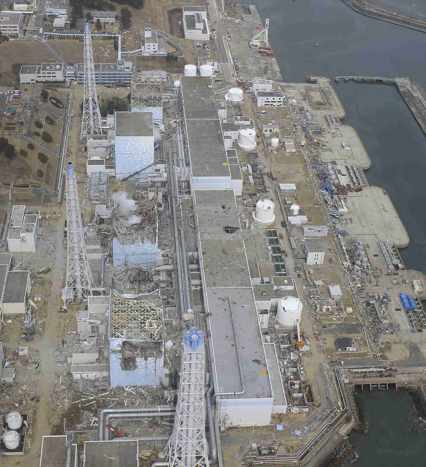
1 April 2011. A2 sends: High quality, detailed video of the plant shot on 24 March 2011:
Fukushima Daiichi Nuclear Plant Hi-Res Photos
Photos shown are half-size of the originals. The 10 originals full-size: http://cryptome.org/eyeball/daiichi-npp ... photos.zip (11.5MB)
24 March 2011
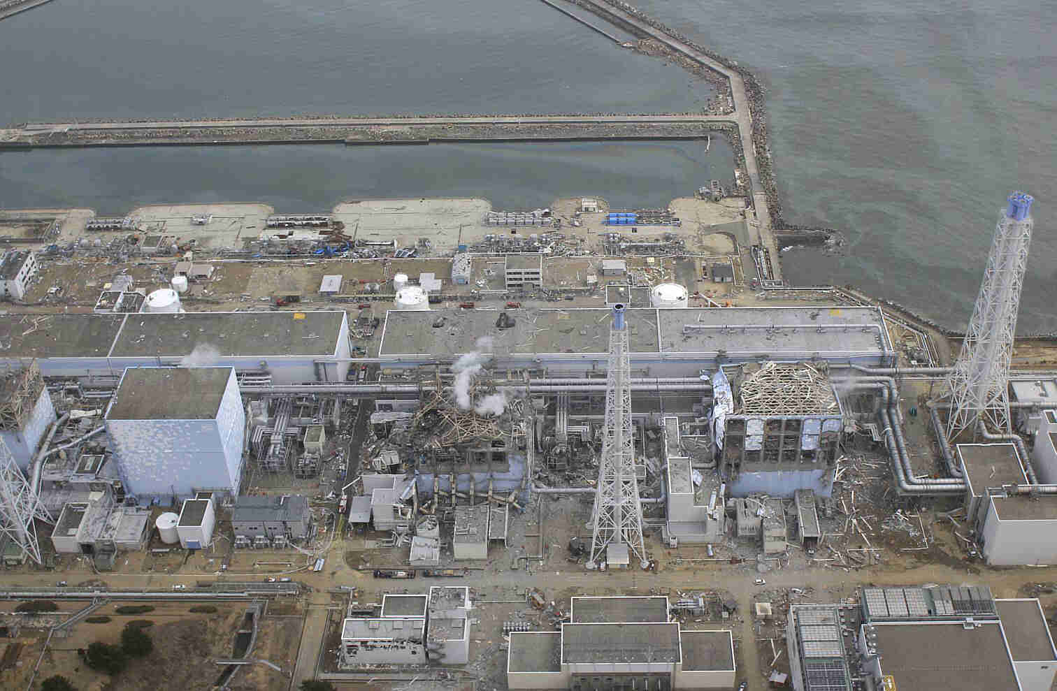
In this March 24, 2011 aerial photo taken by a small unmanned drone and released by AIR PHOTO SERVICE, damaged Unit 3, left, and Unit 4 of the crippled Fukushima Dai-ichi nuclear power plant are seen in Okumamachi, Fukushima prefecture, northern Japan. (Air Photo Service Co. Ltd., Japan)
24 March 2011
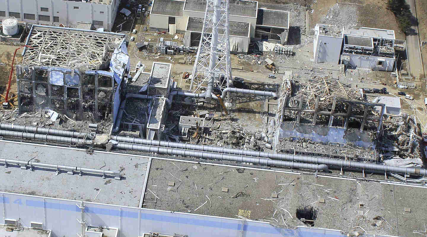
In this March 24, 2011 aerial photo taken by a small unmanned drone and released by AIR PHOTO SERVICE, Unit 4, left, and Unit 3 of the crippled Fukushima Dai-ichi nuclear power plant are seen in Okumamachi, Fukushima prefecture, northern Japan. (Air Photo Service Co. Ltd., Japan)
24 March 2011

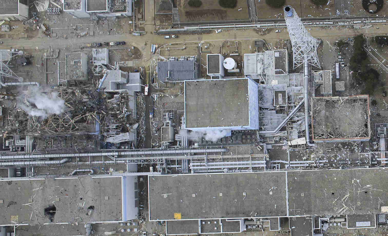
In this March 24, 2011 aerial photo taken by a small unmanned drone and released by AIR PHOTO SERVICE, damaged Unit 3 of the crippled Fukushima Dai-ichi nuclear power plant is seen in Okumamachi, Fukushima prefecture, northern Japan. (Air Photo Service Co. Ltd., Japan)
24 March 2011
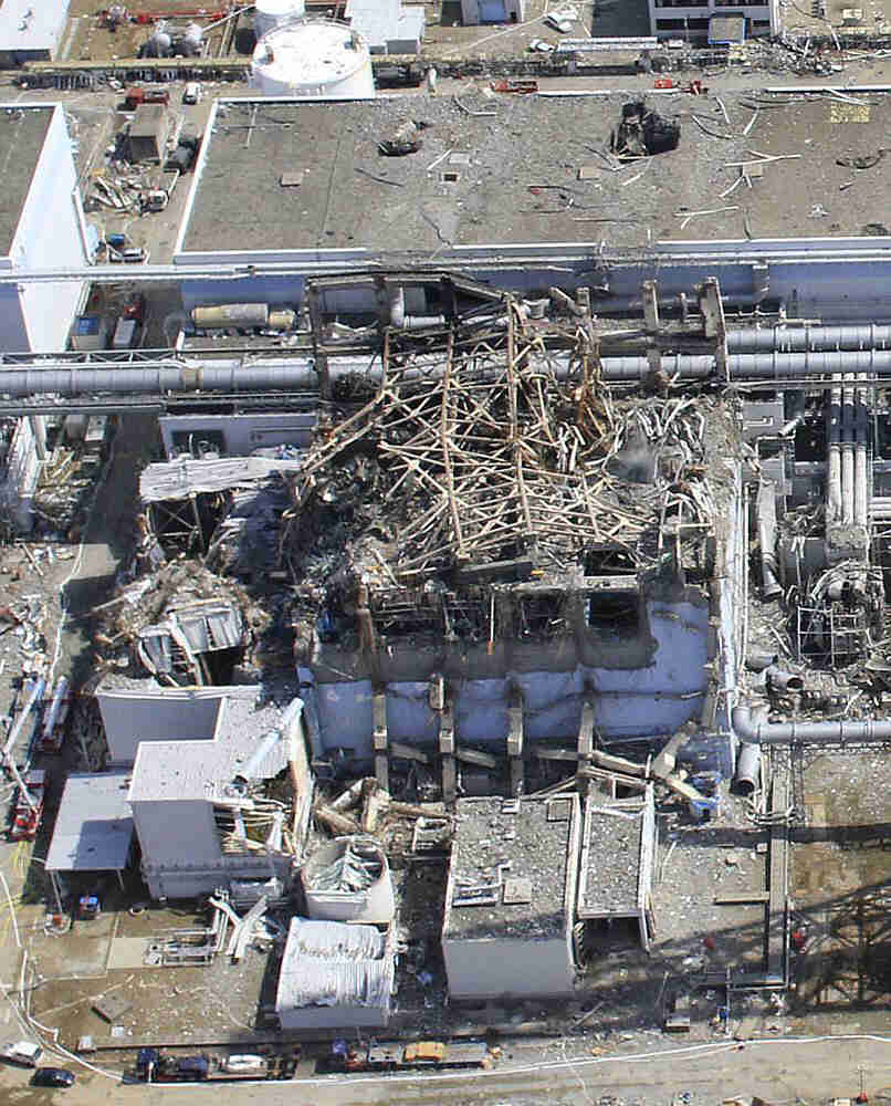
This March 24, 2011 aerial photo taken by a small unmanned drone and released by AIR PHOTO SERVICE shows damaged Unit 3 of the crippled Fukushima Dai-ichi nuclear power plant in Okumamachi, Fukushima Prefecture, northeastern Japan. (Air Photo Service Co. Ltd., Japan)
24 March 2011
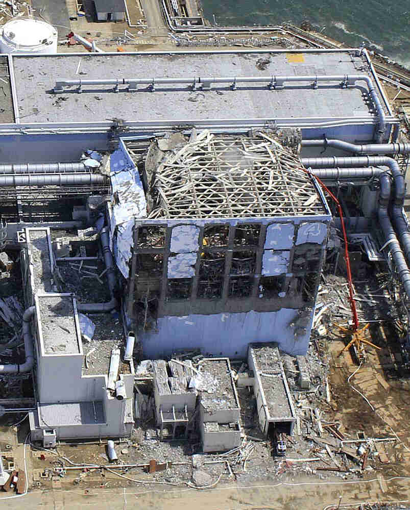
This March 24, 2011 aerial photo taken by a small unmanned drone and released by AIR PHOTO SERVICE shows damaged Unit 4 of the crippled Fukushima Dai-ichi nuclear power plant in Okumamachi, Fukushima prefecture, northern Japan. (Air Photo Service Co. Ltd., Japan)
20 March 2011
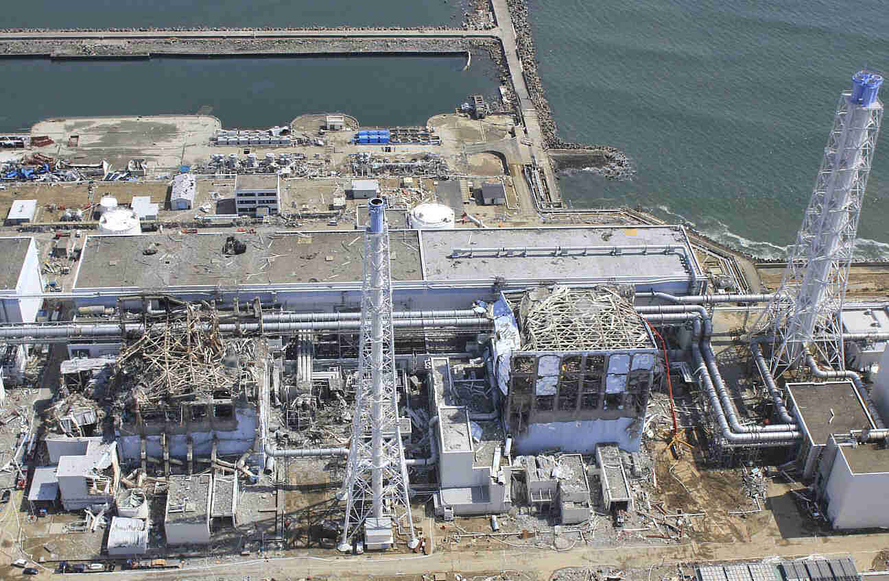
In this March 20, 2011 aerial photo taken by a small unmanned drone and released by AIR PHOTO SERVICE, the crippled Fukushima Dai-ichi nuclear power plant is seen in Okumamachi, Fukushima prefecture, northern Japan. From top to bottom: Unit 1, Unit 2, Unit 3 and Unit 4. (Air Photo Service Co. Ltd., Japan)
20 March 2011

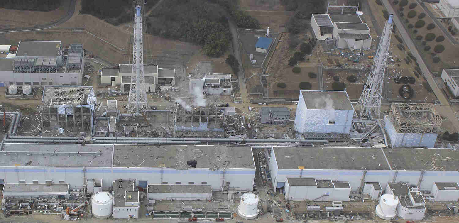
In this March 20, 2011 aerial photo taken by a small unmanned drone and released by AIR PHOTO SERVICE, damaged Unit 4, left, and Unit 3 of the crippled Fukushima Dai-ichi nuclear power plant are seen in Okumamachi, Fukushima prefecture, northern Japan. (Air Photo Service Co. Ltd., Japan)
20 March 2011
In this March 20, 2011 aerial photo taken by a small unmanned drone and released by AIR PHOTO SERVICE, the crippled Fukushima Dai-ichi nuclear power plant are seen in Okumamachi, Fukushima prefecture, northern Japan. From left: Unit 1, partially seen; Unit 2, Unit 3 and Unit 4. (Air Photo Service Co. Ltd., Japan)
20 March 2011
In this March 20, 2011 aerial photo taken by a small unmanned drone and released by AIR PHOTO SERVICE, the crippled Fukushima Dai-ichi nuclear power plant is seen in Okumamachi, Fukushima prefecture, northern Japan. From right to left: Unit 1, Unit 2 and Unit 3. (Air Photo Service Co. Ltd., Japan)
20 March 2011
In this March 20, 2011 aerial photo taken by a small unmanned drone and released by AIR PHOTO SERVICE, the crippled Fukushima Dai-ichi nuclear power plant is seen in Okumamachi, Fukushima prefecture, northern Japan. From right to left: Unit 1, Unit2, Unit 3 and Unit 4. (Air Photo Service Co. Ltd., Japan)
1 April 2011. A2 sends: High quality, detailed video of the plant shot on 24 March 2011:
Fukushima Daiichi Nuclear Plant Hi-Res Photos
Photos shown are half-size of the originals. The 10 originals full-size: http://cryptome.org/eyeball/daiichi-npp ... photos.zip (11.5MB)
24 March 2011
In this March 24, 2011 aerial photo taken by a small unmanned drone and released by AIR PHOTO SERVICE, damaged Unit 3, left, and Unit 4 of the crippled Fukushima Dai-ichi nuclear power plant are seen in Okumamachi, Fukushima prefecture, northern Japan. (Air Photo Service Co. Ltd., Japan)
24 March 2011
In this March 24, 2011 aerial photo taken by a small unmanned drone and released by AIR PHOTO SERVICE, Unit 4, left, and Unit 3 of the crippled Fukushima Dai-ichi nuclear power plant are seen in Okumamachi, Fukushima prefecture, northern Japan. (Air Photo Service Co. Ltd., Japan)
24 March 2011
In this March 24, 2011 aerial photo taken by a small unmanned drone and released by AIR PHOTO SERVICE, damaged Unit 3 of the crippled Fukushima Dai-ichi nuclear power plant is seen in Okumamachi, Fukushima prefecture, northern Japan. (Air Photo Service Co. Ltd., Japan)
24 March 2011
This March 24, 2011 aerial photo taken by a small unmanned drone and released by AIR PHOTO SERVICE shows damaged Unit 3 of the crippled Fukushima Dai-ichi nuclear power plant in Okumamachi, Fukushima Prefecture, northeastern Japan. (Air Photo Service Co. Ltd., Japan)
24 March 2011
This March 24, 2011 aerial photo taken by a small unmanned drone and released by AIR PHOTO SERVICE shows damaged Unit 4 of the crippled Fukushima Dai-ichi nuclear power plant in Okumamachi, Fukushima prefecture, northern Japan. (Air Photo Service Co. Ltd., Japan)
20 March 2011
In this March 20, 2011 aerial photo taken by a small unmanned drone and released by AIR PHOTO SERVICE, the crippled Fukushima Dai-ichi nuclear power plant is seen in Okumamachi, Fukushima prefecture, northern Japan. From top to bottom: Unit 1, Unit 2, Unit 3 and Unit 4. (Air Photo Service Co. Ltd., Japan)
20 March 2011
In this March 20, 2011 aerial photo taken by a small unmanned drone and released by AIR PHOTO SERVICE, damaged Unit 4, left, and Unit 3 of the crippled Fukushima Dai-ichi nuclear power plant are seen in Okumamachi, Fukushima prefecture, northern Japan. (Air Photo Service Co. Ltd., Japan)
20 March 2011
In this March 20, 2011 aerial photo taken by a small unmanned drone and released by AIR PHOTO SERVICE, the crippled Fukushima Dai-ichi nuclear power plant are seen in Okumamachi, Fukushima prefecture, northern Japan. From left: Unit 1, partially seen; Unit 2, Unit 3 and Unit 4. (Air Photo Service Co. Ltd., Japan)
20 March 2011
In this March 20, 2011 aerial photo taken by a small unmanned drone and released by AIR PHOTO SERVICE, the crippled Fukushima Dai-ichi nuclear power plant is seen in Okumamachi, Fukushima prefecture, northern Japan. From right to left: Unit 1, Unit 2 and Unit 3. (Air Photo Service Co. Ltd., Japan)
20 March 2011
In this March 20, 2011 aerial photo taken by a small unmanned drone and released by AIR PHOTO SERVICE, the crippled Fukushima Dai-ichi nuclear power plant is seen in Okumamachi, Fukushima prefecture, northern Japan. From right to left: Unit 1, Unit2, Unit 3 and Unit 4. (Air Photo Service Co. Ltd., Japan)
http://activistnews.blogspot.com/bin laden wrote:I still think bush is the one that did all the shit
-
Why?

- I DON'T MAKE MAPS!!!™
- Posts: 1443
- Joined: Fri Dec 19, 2008 10:09 pm
- Contact:
Re: Giant Earthquake just hit Japan
Sometimes I question why they don't build these things underground.
"Too awesome to play; too legit to quit." — Team Spectator Motto

-
Cc_Hairy
- Posts: 12204
- Joined: Sun May 18, 2003 8:50 pm
- Contact:
Re: Giant Earthquake just hit Japan
Why? wrote:Sometimes I question why they don't build these things underground.

http://www.patspapers.com/story_stack/i ... of_Photos/
Concrete Pumping Robot at Fukushima
http://robotland.blogspot.com/2011/03/c ... shima.html
Attempt To Pour Concrete On Fukushima Crack Generating 1 Sievert/Hour Fails-New Unmanned Drone Pics
http://uk.reuters.com/article/2011/04/0 ... UU20110402
http://www.zerohedge.com/article/attemp ... nned-drone
http://activistnews.blogspot.com/bin laden wrote:I still think bush is the one that did all the shit
-
incandescent

- Posts: 173
- Joined: Mon Mar 14, 2011 10:45 pm
Re: Giant Earthquake just hit Japan
wouldnt all of the nuclear biproduct simply amount undergruond and not go into the ozone so therefore amass and kill every single person? not to mention you'd desecrate the soil if it would go topsideWhy? wrote:Sometimes I question why they don't build these things underground.
This signature has been murdered by a gang of kittens.
-
Why?
- I DON'T MAKE MAPS!!!™
- Posts: 1443
- Joined: Fri Dec 19, 2008 10:09 pm
- Contact:
Re: Giant Earthquake just hit Japan
Can you please grammar this better?incandescent wrote:wouldnt all of the nuclear biproduct simply amount undergruond and not go into the ozone so therefore amass and kill every single person? not to mention you'd desecrate the soil if it would go topsideWhy? wrote:Sometimes I question why they don't build these things underground.
Also @Hairy, love that first pic man. I don't care if it's fake or not.
"Too awesome to play; too legit to quit." — Team Spectator Motto
-
Cc_Hairy
- Posts: 12204
- Joined: Sun May 18, 2003 8:50 pm
- Contact:
Re: Giant Earthquake just hit Japan
Why? wrote:Can you please grammar this better?incandescent wrote:wouldnt all of the nuclear biproduct simply amount undergruond and not go into the ozone so therefore amass and kill every single person? not to mention you'd desecrate the soil if it would go topsideWhy? wrote:Sometimes I question why they don't build these things underground.
Also @Hairy, love that first pic man. I don't care if it's fake or not.
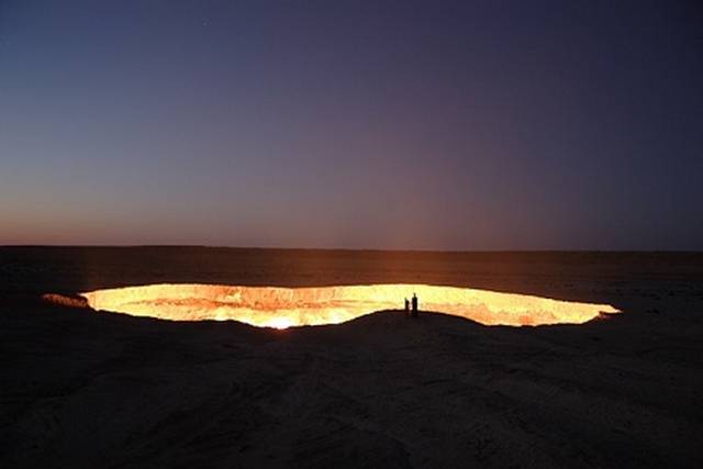
its not fake, its the burning gas crater (sinkhole) in darvaza, turkmenistan, somewhere at the bottom lies the original drill rig that created it (hit a gigantic shallow gas pocket) 38 years ago, geologists set it on fire afterwards and it has burned non stop for 38 years, its a good thing too since the methane that is burning is twenty times more potent a greenhouse gas than the carbon dioxide left after the methane burns off
http://www.newscientist.com/article/mg2 ... ology.htmlTypically a subduction earthquake - in which one tectonic plate pushes beneath another - rips in one or two directions along a fault: on a north-south fault line, say, a rupture heads north, south, or north and south at the same time. But Kiser and his colleagues found that the Tohoku quake ripped left, right and centre along the fault like the starbursts of a fireworks display (see diagram).
"When we imaged the main shock, the propagation of energy was all over the place," says Kiser. "We believe this is the most complex rupture behaviour ever observed." The team reckons the pattern may partially explain why the quake was so ferocious.
Their latest estimates of how far the tectonic plates slid past one another suggest that at its maximum the slip was 60 metres - a figure so big that every researcher New Scientist contacted asked in astonishment for the figure to be repeated. Such a massive shift is unprecedented in the recorded history of earthquakes.
http://maps.google.com/maps/ms?ie=UTF8& ... urce=embed
http://www.bbc.co.uk/news/world-asia-pacific-12722187


Timelapse MP4 video of 5.5 days of aftershocks each second is 3 hours
http://www.iris.edu/dms/products/experi ... shocks.MP4

Observed and predicted Horizontal GPS displacements

Observed and predicted Vertical GPS displacements

Cross-section of slip distribution
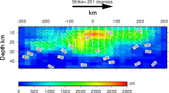
The colors show the slip amplitude and white arrows indicate the direction of motion of the hanging wall relative to the footwall. The colors show the slip amplitude (i.e., the amount by which the land on one side of the fault moved with respect to the land on the other side). The rupture originated about 24 km (15 miles) below the surface. In some places, the slippage along the fault was as large as 30 meters (100 feet), shown by red-shaded areas. The coast of Japan sprang east, into the ocean, in some places by as much as 5 m (16 feet).
Amount of Slip on Fault in Google Earth
http://www.tectonics.caltech.edu/slip_h ... -joint.kml
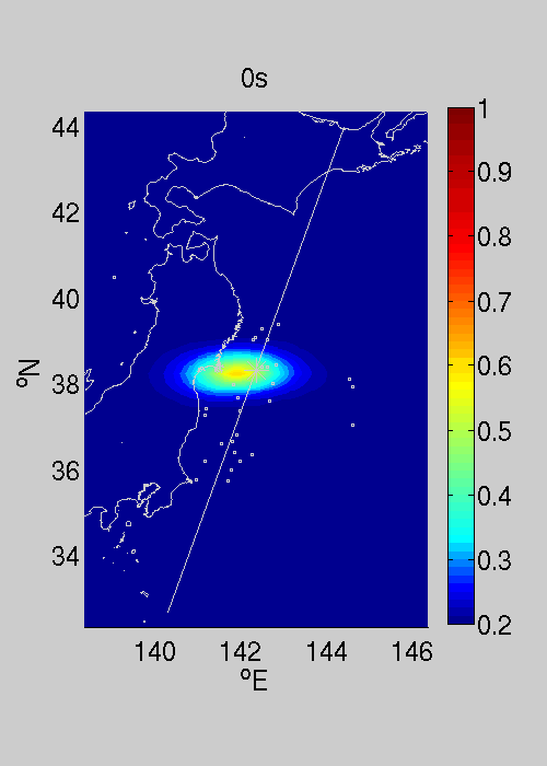
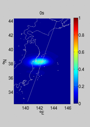
total energy released by mag 6+ quakes in past 108 yearsRupture propagation - Direct imaging of the rupture from back-propagation of seismic waves
We imaged the source of the March 11 2011 M9.0 earthquake in Japan by back-projection of the seismic waveforms recorded by large arrays at teleseismic distance. This source imaging technique allows to track the location and migration of the multiple sources of high-frequency radiation that compose an earthquake rupture front. Our particular approach is based on high-resolution array-processing techniques, such as MUSIC (Mutiple Signal Classification -- Schmidt et al,1982; Goldstein and Archuleta,1991) and CINT (Coherent INTerferometry -- Fletcher et al, 2006; Borcea et al, 2005).These techniques achieve higher resolution than conventional beamforming and are more robust against aliasing.
Data selection and processing
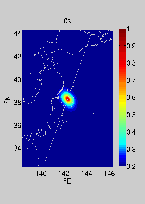
We applied the MUSIC and CINT back-projection techniques to seismic data recorded by the USArray at epicentral distances between 70 and 90 degrees, filtered between 0.5 and 1 HZ within 10 seconds long sliding windows. The large aperture of the USArray in the radial direction provides good spatial resolution along-strike despite its unfavorable source-array direction sub-parallel to the trench axis. Test were also performed using a network of seismological station in Europe (Figure 3) or New-Zealand. The warm colors in the movies (Figures 1 and 2) correspond to high amplitudes of the MUSIC pseudo-spectrum and of the network-averaged cross-correlation coefficient, respectively. They indicate the location of the major areas of high-frequency radiation on the fault. The white star is the mainshock epicenter and the white dots are the epicenters of M>6 foreshocks and aftershocks from NEIC. The white line is a reference along-strike direction on which we project these images to produce the spatio-temporal view of the rupture shown in Figures 4 and 5.
Results
In the initial 100 seconds the rupture propagates slowly to the North and down-dip. Around 100 seconds into the event, two rupture fronts split up. The southward propagating rupture becomes dominant and sustained until 170 seconds.The averaged rupture speed to the south is 2.8 km/s. These features can also be discerned, although with lower resolution, in our back-projection images based on data from Europe (figure 3) and New Zealand.
MUSIC back projection (USArray)
Coherent interferometry (USArray)
MUSIC back projection (dense European network)
http://www.tectonics.caltech.edu/slip_h ... rojection/
the right half is the total energy added for all the 6, 7 & 8's

http://en.wikipedia.org/wiki/Moment_magnitude_scale
http://www.iris.edu/hq/retm
http://www.iris.edu/news/events/japan2011/
http://cegrp.cga.harvard.edu/japan/
http://earthquake.usgs.gov/earthquakes/ ... 1xgp/#maps
http://bcove.me/hw3op4zu
http://activistnews.blogspot.com/bin laden wrote:I still think bush is the one that did all the shit